NorthBeachVacation.com

MOCLIPS RIVER
I rode my bike from the Analyde Gap Road north to the
Moclips River. There's a strip of hard sand just above the
waterline that makes a perfect path for bikes. Cars are also
allowed on this beach too - they drive higher up on the sand.
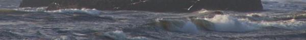
Along my route, I saw fishermen casting into the surf, a
mixed flock of seagulls and crows, sandpipers darting in and
out of the surf, and the sun rising over the cliff and town.
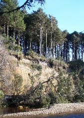
The river forms the boundary between the town of Moclips
and the Quinault Indian Nation. On the QIN side, the
landscape is totally pristine and the cliffside undeveloped.
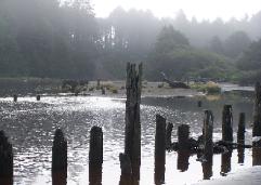
The river is full of old wooden pilings that appear to have
formerly supported a bridge.
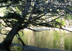
A sandy shoreline extends from the ocean along the river for
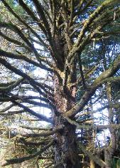
perhaps a half mile. Then a forest grows down to the
riverside on the south side. A rough trail leads through the
forest. Many bare branches reach down low - perfect for
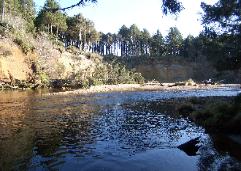
kids to climb on. A short way into the forest, you reach a
bend in the river, where you can see on the opposite shore a
high, tree-topped cliff is being eroded away by the river.
History of Moclips
http://www.moclips.org/regions/mo/moclips.php
by Bob Kelly
bobkelly1964@yahoo.com
http://www.BobsPacificBeachHouse.com
I rode my bike from the Analyde Gap Road north to the
Moclips River. There's a strip of hard sand just above the
waterline that makes a perfect path for bikes. Cars are also
allowed on this beach too - they drive higher up on the sand.
Along my route, I saw fishermen casting into the surf, a
mixed flock of seagulls and crows, sandpipers darting in and
out of the surf, and the sun rising over the cliff and town.
The river forms the boundary between the town of Moclips
and the Quinault Indian Nation. On the QIN side, the
landscape is totally pristine and the cliffside undeveloped.
The river is full of old wooden pilings that appear to have
formerly supported a bridge.
A sandy shoreline extends from the ocean along the river for
perhaps a half mile. Then a forest grows down to the
riverside on the south side. A rough trail leads through the
forest. Many bare branches reach down low - perfect for
kids to climb on. A short way into the forest, you reach a
bend in the river, where you can see on the opposite shore a
high, tree-topped cliff is being eroded away by the river.
History of Moclips
http://www.moclips.org/regions/mo/moclips.php
by Bob Kelly
bobkelly1964@yahoo.com
http://www.BobsPacificBeachHouse.com
Plan your Washington Coast Vacation at...
 |
| |
 |
| |
 |
| |
 |
| |
 |
I want to visit...
COPALIS GHOST FOREST
COPALIS ROCK
DAMON POINT STATE PARK
DUCK LAKE
GRAYLAND BEACH STATE PARK
GRAYS HARBOR LIGHTHOUSE
GRAYS HARBOR NWR
GRIFFITHS-PRIDAY PARK
HIGLEY PEAK
HOH RAIN FOREST
HOQUIAM INDOOR WATERPARK
KALALOCH BEACH 2
KALALOCH LODGE
KESTNER HOMESTEAD
LAKE QUINAULT LODGE
LAKE QUINAULT LOOP DRIVE
LAKE SYLVIA STATE PARK
LAKE WYNOOCHEE
MAPLE GLADE TRAIL
MOCLIPS RIVER
MONTESANO COURTHOUSE
MUSEUM OF THE NORTH BEACH
NORTH JETTY
OCEAN CITY STATE PARK
OCEAN CREST RECREATION CENTER
PACIFIC BEACH STATE PARK
POINT GRENVILLE
QUINAULT BIG CEDAR
QUINAULT BIG SPRUCE
QUINAULT INDIAN CASINO
RAIN FOREST LOOP TRAIL
RAZOR CLAM DIG
RUBY BEACH
SEABROOK
SUNSET BEACH
TAHOLAH
WESTHAVEN STATE PARK
WESTPORT